Anthony on , , , , 22 Aug 2008 09:03 pm

Today, I took Sean (brother-in-law) “up into the mountains”.  This is his first visit to BC, and wanted to see some of the BC mountains.  The weather’s been pretty miserable for the week he’s been here, but the weather prognosticators indicated that they expected today to be better than the rest of the preceding (and following) days so I swapped my Labour Day holiday with today.

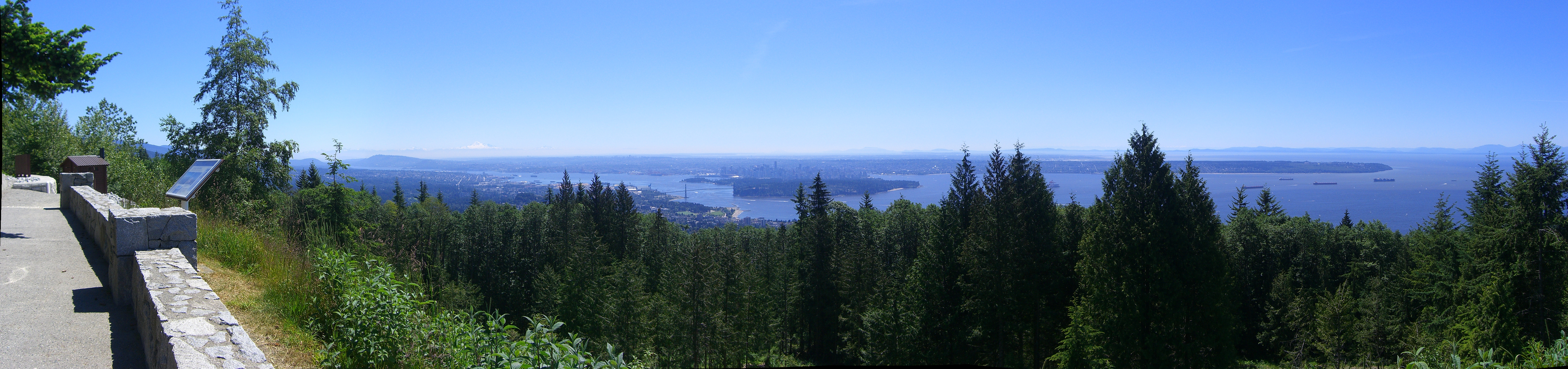
We got up late, had a largish breakfast and made it to Cypress Bowl by about 11:30 am.  It was mostly sunny, with some puffy clouds haunting the mountain peaks.  Gwen dropped us off in the parking lot with a promise to pick us up around 6 pm.

The Mt. Strachan (pronounced “Strawn”) hike is one I’ve done at least a half-dozen times and is one of my favourites.  It starts in the Cypress Bowl parking lot and then you take the Howe Sound Crest Trail for about an hour towards The Lions.  Eventually you come to a meadow on the west side of Mt. Strachan and a short trail to a ravine the goes up to a pass between the North and South peaks of the mountain.  Climbing up the ravine (which is quite steep) is quite an endeavour.

It's steeper than it looks!

It's steeper than it looks!

Snow still in the ravine

Snow still in the ravine

Lions look-off half way up

Lions look-off half way up

Once you achieve the pass, you climb up a similarly steep trail to gain the North Peak.  The view from the top is quite amazing, with a 360° view. The clouds broke just as we summited, making for the typical outstanding view.

Sean at the top of Mt Strachan

Sean at the top of Mt Strachan

After rehydrating and chowing down a bit, we climbed down the North Peak and ascended the South Peak.  Along the way, we grabbed a geocache that hadn’t been found this year and had only been found once last year.  The South Peak is the top of chair lifts for Cypress Mountain, and the hike down from the South Peak parallels the ski runs a bit, and about 2/3 of the way down, you are actually forced to walk along the access road/ski run.

We were within view of the parking lot by about 3:30 pm — clearly we made much better time than I expected — and gave Gwen a call.  We made it down to the parking lot soon enough and then beat it over to the nearby Yew Lake to pick up another geocache before meeting Gwen and Aidan in the parking lot. And the rain held off until we were waiting to be picked up!

Yew Lake

Yew Lake

All in all, 8.8 km hiking, 730 m total elevation gain, about 4.5 hours total time including breaks.

The GPS track is shown below, along with a Google Earth plot of the hike.

Mt. Strachan hike

Mt. Strachan hike

Anthony on , , 16 Aug 2008 04:46 pm

I was chatting with my mother last week, and she had mentioned how she and Dad were out caching a few weeks ago and managed to scratch the BBT up a little bit.  That reminded me of the 3 province geocaching trip that Gwen, Aidan, and I took while we were back east in the spring.  Not because we scratched the truck up, but because we certainly took it places of the like it hadn’t been too much.

According to my geocaching logs, it was May 30th, 2008.  It was a nice sunny day and our plan was to drive to PEI via the Confederation Bridge.  We were going to cache along the way, making sure that we got caches in each province.  We made the decision that we weren’t going to try for any caches until we got north of Truro, and so the first one that Gwen picked out (we had a Pocket Query that found all the caches along our route within 100m of the highway) was GC16EQC Blueberry Fields.  The cache description, though brief, sounded alright and so we went for it.

The directions on the cache page are simply:

Do not stop or park on highway 104 to access this cache. You can get to this cache by exiting at exits 8 or 10, depending on the direction you are coming from. This way you will see the beautiful scenery and also avoid the toll on the Highway.

As we were heading north, we took Exit 10.  This was the Bass River Road, leading into Londonderry.  A typical Nova Scotia rural road.  The GPS then routed us north again … and then most unexpectantly the pavement disappeared.

In fact, we were driving on a dirt road for the next 25 km or so.  As dirt roads go, it was in very good shape, probably having been repaired after the winter.  In fact, it was in better shape than some of the paved roads up around Amherst (Hi Buffy!  She’s the engineer at NSDOT responsible for roads in Cumberland County.  It was a tough winter apparently).

I’ve got a fair bit of experience driving dirt roads now (Gwen and I drove up to Iqaluit — and back —  on the Dempster Highway in 2004 and it’s 99% unpaved) so it was a fun drive.  Well, other than the fact we really didn’t know where we were going.  OK, so we had the GPS with us, but still.

Anyway, after some time of driving along the dirt road, we came to a nice overpass crossing the TransCanada.  The bridge was paved, but the approaches weren’t.  Weird.  I guess that’s what happens when you have a private company build and operate the Cobequid Bypass.

A short time after that, we arrived at the “Pioneer Graveyard” that served as parking for the cache.


Westchester Mountain Pioneer Cemetery

Westchester Mountain Pioneer Cemetery

Westchester Mountain Pioneer Graves

Westchester Mountain Pioneer Graves

We hoofed it up into the graveyard and happened upon a snowmobile trail.  The cache itself seemed to be directly ahead of us, but the trail ran perpendicular to that.  After a short walk in the wrong direction, we turned around and followed the trail to the cache.

Which was up quite a hill.


Snowmobile Trails Leading to Blueberry Fields

Snowmobile Trails Leading to Blueberry Fields


Within spitting distance of the TCH.

Aidan Retrieves the Blueberry Fields Cache

Aidan Retrieves the Blueberry Fields Cache


Having cleverly located and signed the cache, we went back to the truck and tried to figure out how to get back to the highway.  The easiest thing seemed to be to go to the overpass and see if there was any way to get on the highway from there.  After rolling back and forth across the bridge a few times, it was pretty clear that we weren’t going to be able to do that — at least not with the truck we had.  So, the only options were to retrace our path or to continue along the same dirt road (which was the route the GPS suggested).

Onward!

In actuality, the trip out was much shorter and we soon regained pavement.  After that, it was a short drive to Exit 8 to get back on the highway and continue to New Brunswick.

All totalled, we probably spent in the neighbourhood of 3 hours getting to and finding that one cache.  Not a great start to our tri-province caching adventure in terms of efficiency, but we had fun finding it.  You can read my log here.  I’ve provided a handy map below too, detailing the excursion.


View Larger Map

Anthony on , , , , , , 29 Jul 2008 09:29 pm

This weekend past, we took Kayla to stay with a friend she had in Halifax who now lives in Metchosin.  This involved getting everyone up and going early Saturday morning to head to Tsawwassen to catch the 8 am ferry.  Early was leaving the house at 6:30 am.

It was a nice trip across to the Island, lots of sunshine, calm waters, and not too chilly.

After a stop in Sidney to grab some breakfast from Smitty’s, we headed to Metchosin.  Metchosin is south-west of Victoria.  Getting to Kayla’s friend’s house was interesting … we had the wrong street address and the GPS took us to a place that didn’t make a lot of sense.  With a little bit of a description from Kayla and the belief that we couldn’t be that far out, we eventually found the base (CFAD Rocky Point) and appropriate PMQ where her friend is living. Good thing because it turned out that none of the 3 cell phones we had with us were getting signals that far out.

We dropped Kayla off and headed over to visit with my cousins Mike and Gert and their kids.  It’s been quite some time since I’ve seen Mike’s kids, and wow, they’ve grown.  We visited a short while and then the 3 of us headed out with Mike to do some geocaching on the grounds of Royal Roads University.  Mike has one of those high-sensitivity GPSr’s (a Garmin Rhino) and was getting much better reception than we were.  Even still, he was smoking hot, nabbing all the 5 or 6 caches we got that afternoon (well, actually Gert got one too).  Gert came and met us half way there.  Aidan, unsurprisingly, took quite a shine to Gert.

We headed back and had supper with Mike and Gert and their daughter Marie.  After a great supper, we drove up the Malahat to Nanaimo to stay the night before heading up to Campbell River the next day.

It was the first time we’ve stayed with Aidan in a hotel room.  It was rough.  He just wouldn’t go to sleep, insisting on talking to us and singing.  When the fireworks started going off (no, seriously, fireworks) at 10 pm, fortunately he was asleep.

We found out that night that our Sunday plans had changed and instead of going up to Campbell River, we were going to meet my Aunt Jean in Nanaimo.  That meant we had some time to kill that morning, so we decided to do some geocaching.  Well, none of us slept particularly well, so you can imagine the moods we were all in.  Cranky 3 yr old, cranky 34 yr old and cranky and pregnant 30-something.  Adding to the geocaching difficulty were the Nanaimo bath tub races.  Muggles everywhere!

We only managed to grab two caches, one  of them down near the berth of one of the new “Super-C” class ferries.

After a bit of communication SNAFU, we found Aunt Jean on the edge of Nanaimo.  Yes, found.  The GPS came in pretty handy.

After lunch with Aunt Jean (note: Aidan has been saying “See you later, Sunshine” since then) it was a leisurely meander back down towards Victoria.  We stopped in Cowichan Bay and grabbed some artisan cheese (from Hillary’s) and bread from the wonderful “slow food” stroll along the shoreline there.  After Cowichan Bay, we headed into the Cowichan Valley and stopped by the Merridale Cidery and I picked up some hard apple cider.  I had been to both places while participating in the Grape Escape 3 years ago.

After that, it was pretty routine.  We headed back to Metchosin (and took some pictures along the way) picked up Kayla (Aidan really missed her) and headed back up the highway to the ferry.

Good thing we had reservations … we would have had a one or two sailing wait otherwise.  We were a little bit late leaving and didn’t pull into Tsawwassen until 10 pm.

Whew, what a long weekend.  Then the hike yesterday.  Now, it’s 9 pm and I’m ready for bed.

Anthony on , , , , , 29 Jun 2008 10:07 pm

Record breaking heat this weekend.  Cold and wet start to June (the local weather personalities were calling it “June-uary” — which got real old, real quick) and now blue sky and scorching heat.  Welcome to the dry season.

This weekend was busy doing an assortment of things.  Saturday was chores and errands in the morning, a quick trip (hah!) to Highview Lookout in Cypress Provincial Park for some photos and cache placement scouting, and then over to the COINANZA geocaching event in the Barnet Marine Park in north Burnaby.  Aidan had a good time playing in the sand and watching the trains whiz by as we socialized.  If you go through the photos at the event, you’ll see Aidan made it again. :) Grocery shopping after that, and then Aidan and I went by bike back to the grocery store because I forgot to get the one thing we were supposed to get — hamburger buns (for supper).  Doh!

Full size (10 MB)

And, oh, we also picked up a travel bug at the event:

Today was a bit more of the same.  Back to Cypress to drop off a geocache that we’re placing (not published yet, link to come) and then to the Wal*mart in North Van to get The Boy some summer jammies.  Back home for a nap that didn’t come and then we beat it down to Spanish Banks for a picnic on the beach.  Whew.

What kind of bug is this?  Anyone?  It was on the beach where we were trying to picnic:

You know, the views in Vancouver never get old.

Full size (9.5 MB)

« Previous PageNext Page »